We entered Alberta on Tuesday the 27th of August
on the Trans-Canada Highway east of Medicine Hat, and continued northeast to
Brooks. The stretch of highway from
Medicine Hat to Brooks has got to be one of the most boring in the country,
being flat, straight, and with hardly anything beside cattle and hay fields to
look at. We left the TCH just west of
Brooks and headed north and then west into the Red Deer River valley a bit east
of Drumheller, where we stopped at the Hoodoos and walked around in “the
Badlands” for a while. A short distance
further west is the relatively new Hoodoos Campground, where we stayed for the
night in a nice grassed site close to the river. Before starting dinner we all went for a
swim/wade in the river, which is quite shallow at this location.
At the Hoodoos, near Drumheller
Red Deer River at Hoodoos Campground
On Wednesday morning we left camp and drove a short distance
east to the Rosedale suspension bridge, which was built about a century ago for
miners to get across the river. Then it
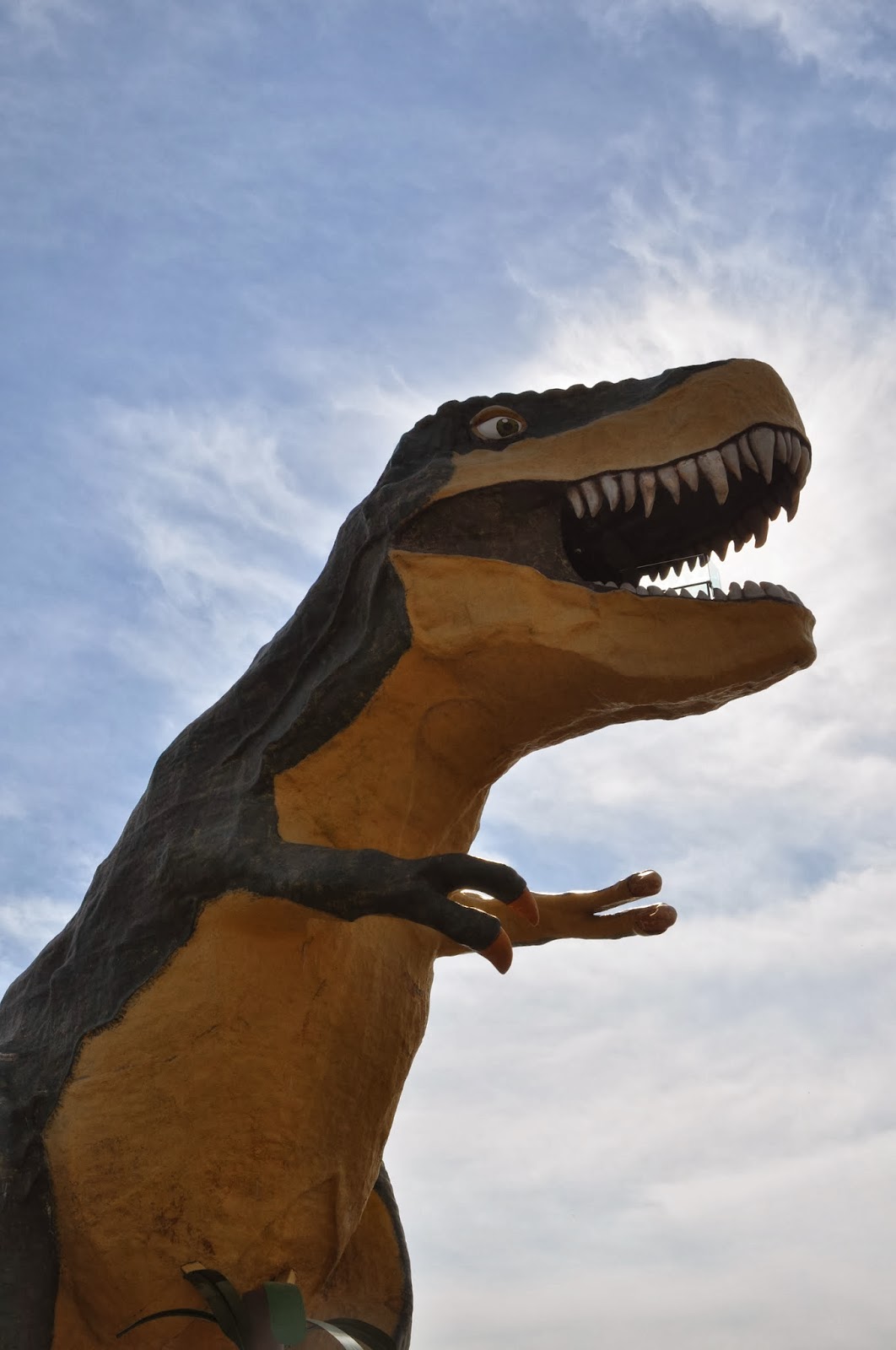
was into Drumheller, where the girls had to climb up inside the statue of the
“World’s Largest Dinosaur”, a model of a T-Rex approximately 4 times the size
that the animal actually was. They also
climbed on a true-size statue later. We
then continued to the Royal Tyrell Museum, where we spent more than two
hours. I had never been there, and it is
much bigger and better than Rhonda remembers from several years ago. After that we drove northeast to Horsethief
Canyon and walked around a bit more in the badlands. From there we had planned to do a circle
drive around the Badlands, but that involved taking a cable ferry across the
river, and when we got to the ferry we found it to be “temporarily closed”
until 10:00 AM the next day. So we
backtracked, and headed out towards Calgary, with a brief stop at Horseshoe
Canyon.


At Rosedale Suspension Bridge
At Drumheller
Inside the Royal Tyrell Museum
Alberta Badlands at Horsethief Canyon
My cousin Janet (see PEI blog entry) had been busy “rounding
up the troops” for a big family dinner at her place, so we could get together
with as many of my relatives as possible.
She had also done some checking and determined that parking an RV on the
street in her neighbourhood would not be allowed, but that there was an RV
campground relatively nearby. So we
headed to Mountain View Campground, in Chestermere just east of Calgary, which
was expensive and had the units packed very closely together, but was OK as a
place to sleep. As arranged, we texted
her when we arrived, and shortly after that my cousin Bob (her brother) arrived
to take us to the party. Besides Janet,
Shane, and the boys, whom we had visited with in PEI, others that were able to come
were Janet’s parents - my Uncle Jerry (my mom’s oldest brother) and Aunt
Joanne, the aforementioned Bob, and Bob and Janet’s younger sister Stacey (also
my cousin, of course) with her kids Emma, Abby and Cole. In addition, my Uncle Doug (my mom and Uncle
Jerry’s) younger brother, his wife Joan, his daughter (my cousin) Wendy, and
Wendy’s daughter Ella were there. All
told, 15 of my relatives and family members were able to come out and spend
some time with us on pretty short notice, and we were very pleased. We had a wonderful roast beef dinner, with
two kinds of pie for dessert (mostly prepared by Joanne), and the kids all had
lots of fun playing together. We stayed
a little longer after everybody else had left, talking and playing cards, and
then Shane drove us back to the campground. It was a great and very busy day.

With my "little" cousin Bob
Group Photo at Janet and Shane's place (some had already left by then)
We had initially planned to spend two nights (one full day)
in the Calgary area, but we had seen everybody were able to see on Wednesday
night, and besides, the zoo, which is one of the coolest things about Calgary,
was still closed due to the flooding in late June. So we just packed up, and headed to Costco
for the third time in four days, to get cheap gas and booze as well as more
groceries. Then we headed south to High
River, the town where my mom (as well as her brothers) was born and raised,
which was hit even harder than Calgary in the June floods. The house that I remember as my grandparents’
house is up on a hill and was fine, but the whole downtown and adjacent
residential areas are still a disaster zone, more than two months after the
event. We saw very few open businesses,
banks operating out of trailers, twisted and undermined railway tracks, and
multiple buildings with the lower floors gutted and under renovation. This includes the two houses my mom and uncles
lived in, although the bigger house, which was originally my
great-grandparents’ (and is still known locally as “the Young house” even
though the current owners have been there for 30 years), which Uncle Doug says
they are trying hard to save (he was recently talking with the owners). We then went to the cemetery, which is huge,
and I was unable to locate the headstones of my grandparents or
great-grandparents, although I did see markers for several other people that I
recognized.
Flood Damage, High River area
From High River we headed west towards the mountains,
passing through Longview and then north through Turner Valley and Bragg Creek
to the TCH west of Calgary. It wasn’t
just the Bow River at Calgary and the Highwood at High River that were hit by
the flooding – we also saw a lot of damage along streams like Sheep Creek and
the Elbow River. Being the history and geography nerd that I am
(I truly believe that, had I chosen a
different career path I would have been an awesome social studies teacher – but
I digress …), as the mountains came more into focus I couldn’t help thinking of
the scene from the CBC classic “The National Dream” (based on the Pierre Berton
book of the same name, and it’s sequel “The Last Spike”), where William
Cornelius van Horne, the manager/engineer credited with completing the CPR,
says to Father Lacombe about what has his undivided attention: “It’s out there,
Father (gesturing to the west) – those mountains. They’re in my way”. Anyway, upon reaching the TCH we continued
west into those mountains to Banff, where we checked out the Cave and Basin National
Historic Site (the hot springs where Canada’s national park system was
born). Then it was on to Lake Louise,
where we stopped briefly at the lake before heading west into BC. Unfortunately it was a bit cloudy, so the
view was not as spectacular as it sometimes is, but it is still a pretty
magical place. Surprisingly, the only
wildlife that we saw in Banff National Park was two deer that ran in front of
us just as we were entering the Banff townsite.


